Imaging the Earth’s interior has always been one of the key challenges in Earth sciences, as it is a prerequisite for understanding the internal dynamics of our planet and the coupling between its inner and outer shells. Measurements of gravitational acceleration at different altitudes (ground-based, airborne, and space-based observations) are a unique imaging tool because they provide direct information about mass changes at different spatiotemporal scales. After decades of research, development, and industrial transfers, quantum technology has reached a high level of maturity, and it is now possible to deliver operational quantum gravimeters offering various advantages over the devices that have been used to date.
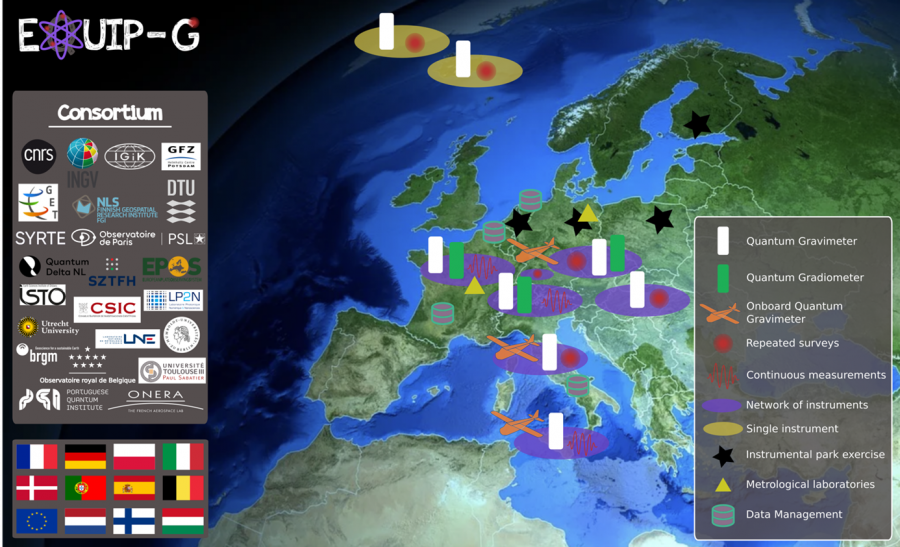
In line with the objective of strengthening the EU’s strategic autonomy and competitiveness, the EQUIP-G (“European QUantum Infrastructure Project for Gravimetry”) project, proposed by a consortium of 20 partners from 11 European countries, has been selected to develop and implement a network of quantum gravimeters in Europe. The project is led by the Laboratoire Temps Espace (Observatoire de Paris).
This will be the first step towards establishing the ground segment of a pan-European quantum gravimetry infrastructure, centered around a shared instrument park. To this end, quantum gravimeters, quantum gradiometers, and a quantum gravimeter operating on a mobile platform will be used. These instruments will be comprehensively tested before being deployed in the field. As part of EQUIP-G, we will demonstrate, using innovative measurement strategies, the ability of the quantum gravimetry network to contribute to EU priorities such as the Green Deal, energy management, and risk mitigation. Metrological supervision will ensure that all gravimetric data collected from quantum gravimeters is consistent with international SI standards. The data will be managed in accordance with FAIR* principles and with a long-term perspective of establishing a TCS (Thematic Core Service) for gravimetry within EPOS (European Plate Observing System). EQUIP-G will engage in strong community building, aiming to involve the entire European gravimetry community in the development of a long-term Instrumental Park initiative that will continue beyond the end of the project, democratizing the use of quantum sensors manufactured in Europe.
As part of the project, the Institute of Geodesy and Cartography will, among other things, lead Work Package 2, which aims to ensure comprehensive quality control of all gravimeters used in the project, with particular emphasis on newly acquired quantum sensors. A key part of the project will involve determining measurement consistency with Si units.
Project website: https://cordis.europa.eu/project/id/101215427
* The FAIR principles (Findable, Accessible, Interoperable, Reusable) describe how data should be organized to facilitate access, understanding, exchange, and reuse.