The Horizon Europe EQUIP-G project started on 1st of June.
Imaging the Earth’s interior has always been one of the key challenges in geosciences as it is a prerequisite for understanding our planet’s internal dynamics and the coupling between its inner and outer envelopes. Gravity measurements at different altitudes (ground, airborne and space-based observations) provide a unique imaging tool, as they supply direct information on mass changes at different spatio-temporal scales. Following decades of research, developments and industrial transfers, quantum technology reached a high level of maturity and is now possible to deliver operational quantum gravimeters offering various advantages with respect to devices that have been hitherto used.
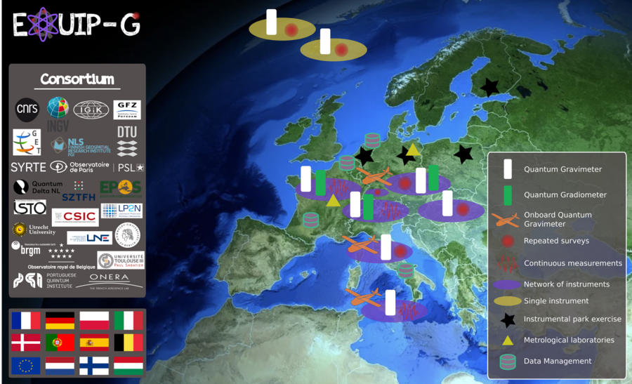
Aligned with the objective of strengthening EU’s strategic autonomy and competitiveness, EQUIP-G („European QUantum Infrastructure Project for Gravimetry”) project proposed by a consortium of 20 partners of 11 European countries, has been selected to develop and deploy a network of quantum gravimeters in Europe. Project is led by Laboratoire Temps Espace (Observatoire de Paris).
This will represent the first step towards establishing the terrestrial segment of the pan-European quantum gravimetry infrastructure, revolving around a shared Instrumental Park. For this purpose, quantum gravimeters, dual quantum gravi-gradiometers and an onboard quantum gravimeter will be employed. These instruments will be comprehensively tested, before being deployed in the field. In EQUIP-G, we will demonstrate, through innovative measurement strategies, the ability of the quantum gravity network to contribute to EU priorities, such as Green Deal, energy management and risk mitigation. Metrological oversight will ensure that all collected quantum gravity data will be SI traceable. Data will be managed in line with the FAIR principles* and with a long-term perspective to establish a TCS (Thematic Core Service) for gravimetry within EPOS (European Plate Observing System). EQUIP-G will engage in strong community building, aimed at involving the whole European gravimetry community in the development of the long-term Instrumental Park initiative that will extend beyond the end of the project, democratizing the use of quantum gravity devices produced in Europe.
Within the project Institute of Geodesy and Cartography will, among other tasks, lead the Work Package 2 aiming to provide comprehensive quality control to all gravity instrumentation used in the project with the focus on newly acquired quantum sensors. Crucial part of the project will involve establishing traceability of instrumentation used in the project to SI.
Project page: https://cordis.europa.eu/project/id/101215427
* FAIR principles (Findable, Accessible, Interoperable, Reusable) describe how data should be organised to make it easier to access, understand, exchange and reuse.