Remote sensing techniques for the assessment of carbon balance
Project coordinator: prof. dr hab. Katarzyna Dabrowska-Zielinska
Project number: 98101
Duration of the project: 1.06.2011 – 30.06.2013
Study and implement remote sensing techniques for the assessment of carbon balances for different biomasses and soil moistures within various ecosystems
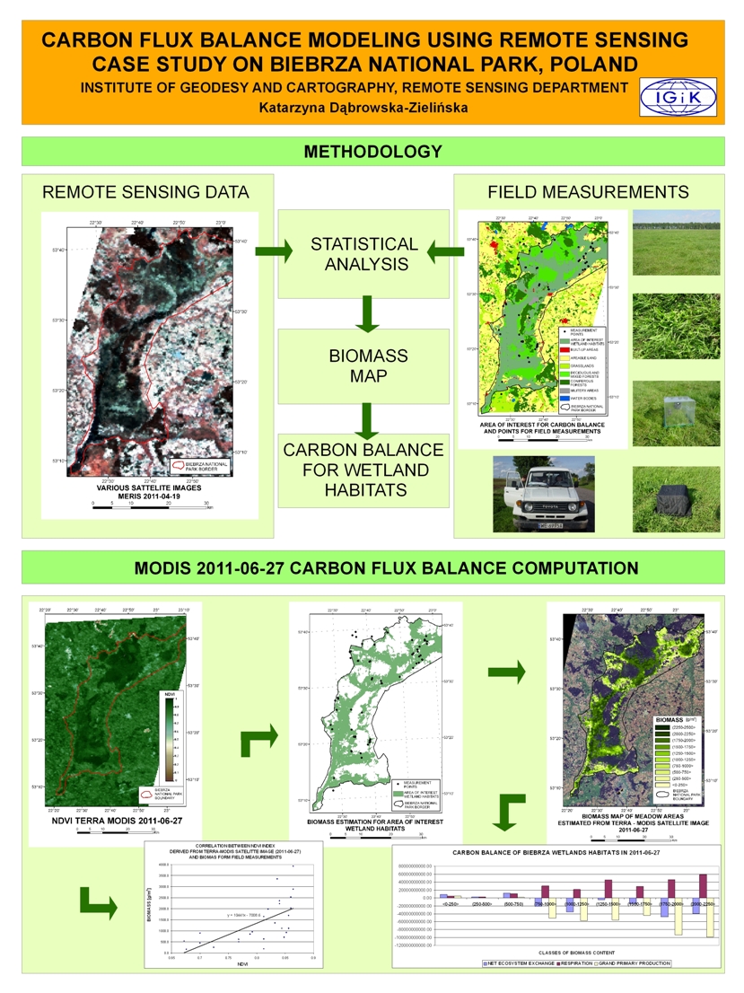
The objective of the ESA PECS CARBON Project is to assess level of carbon balance with regard to land use, the amount of biomass, the soil moisture and meteorological conditions. The project also assessed the influence of the land use cover on carbon release and sequestration. Data gathered by various satellites were used in this project. The thematic scope of the project makes an explicit reference to the current policy of the Ministry of Environment in Poland, expressed by biodiversity activities regarded to carbon balance and Climate Change.
 The following tasks were carried out in the course of the project:
- Mapping of the land use with special attention to forest area changes, bio-energy plants and wetland areas;
- Measurements of the soil moisture in different vegetation areas by applying the L- band radiometer and TDR measurements in order to validate ASAR and PALSAR data;
- Measurements of variations of carbon fluxes for areas covered by various vegetation types.
Spatial emphasis was also put on the wetland areas in terms of changes of soil moisture (source of methane).
The satellite data were used for the model of assessing the carbon balance. The data indispensable to run this model such as soil moisture were calculated from ASAR measurements. Biomass and height of vegetation were obtained from long microwave data as ALOS PALSAR and in the nearest· future· from dedicated BIOMASS MISSION P-SAR band, which was essential and very important for estimation of forest biomass. Also biomass was estimated for low vegetation using TerraSAR-X data and optical data acquired by following satellite sensors: VEGETATION, MERIS, AATSR installed on SPOT and ENVISAT satellites. Also the information on CO2 and CH4 content derived from data collected by Envisat-Sciamachy sensor were very important source of information both to estimate the carbon balance as well as to verify information obtained from satellites by means of data measured at the ground.
The remote sensing information came from various satellite sensors:
ENVISAT Sciamachy - C02; CH4;
ENVISAT ASAR;
ALOS - PALSAR;
TerraSAR-X BIOMASS Mission Sensors.
Also optical data acquired by VEGETATION instruments on SPOT-4 and SPOT-5, the Along Track Scanning Radiometer-2 (ATSR-2) on ERS-2, plus the Advanced Along Track Radiometer (AATSR) and Medium Resolution Imaging Spectrometer (MERIS) on ENVISAT will be applied in the project.
The Project improved the availability of data and information needed to implement the EU Directives - it was related to activities conducted within the Air Pollution Directive - 96/61/EC.
The Project is consistent with the following ESA Projects:
- GMES Service Element Land - Core Information Services
- GLOBECARBON and GLOBWETLAND
- BIOMASS Mission
- PROtocol Monitoring for the GMES Service Element; EOEP-2; PROMOTE GMES
as well as with ESA AO and CAT-1 Projects carried out in the Institute of Geodesy and Cartography::
AO PI 3742 - ALOS ADEN; 3677 ALOS ADEN; CAT-1 1427; CoI AO 122 i INTAS 06-1000028-9182.