SATMIROL Satellite-based crop identification and crop growth monitoring for agricultural statistics
.png)
.jpg)

Satellite-based crop identification and crop growth monitoring for agricultural statistics (SATMIROL)
Funded by: the National Centre for Research and Development; (GOSPOSTRATEG1/381705/13/NCBR/2018)
Project coordinator: Artur Łączyński (GUS), in IGiK: dr Jędrzej Bojanowski
Consortium: IGiK, CBK PAN, GUS
Time frame: 01.01.2019 – 31.12.2021
Project goals
The main objective of the project is to improve the identification and monitoring of agricultural crops for the purpose of agricultural statistics. This is achieved through the development and implementation at Statistics Poland of an innovative system which, based on satellite data from the Copernicus programme, provides annual crop type maps on a national scale and yield forecasts during the ongoing season.
The main objective of the project is achieved through the following activities:
- development of a strategy for building a system for crop identification and monitoring based on COPERNICUS satellite data,
- development of algorithms for satellite-based crop identification (by a project partner: Space Research Centre of the Polish Academy of Sciences),
- development of algorithms for satellite monitoring of crop growth and yield forecasting during the growing season,
- testing of developed algorithms in a pilot study,
- development of dedicated IT infrastructure in Statistics Poland,
- implementation of algorithms taking into account modernization of infrastructure,
- optimization of satellite data processing.
Crop mapping is based on Sentinel-1 radar data. Predictors used for crop yield forecasting consist of meteorological and agro-meteorological data as well as vegetation indices derived from Sentinel-3. The developed system allows: use of satellite data, increased use of data from administrative records, more effective acquisition of target data and at a low level of spatial aggregation, and acquisition of agricultural crop data from processed satellite images instead of labour-intensive preparation of surveys.
Implementation of the SATMIROL system and use of its results is an important aspect in research&development conducted in the field of agricultural statistics. The work undertaken in Statistics Poland aims at introducing innovative methods of data collection and presentation in statistical research. The creation of a pioneer system for identification and monitoring of agricultural crops makes it possible to obtain and present data in a spatial perspective, which is not possible with the currently used data collection methods. The new method of obtaining data makes it possible to present them at all levels of administrative division. A measurable effect of introducing the system is the reduction of the costs of statistical surveys.
The main users of the project results will be ministries, scientific institutes, universities, local self-government units as well as farmers. The implementation of the project will allow achieving economic benefits through partial replacement of work currently carried out under the Programme of Public Statistical Research. The social benefits will result from the provision of more timely data of better quality, which will allow more effective assessment of the situation in agriculture sector and enable more effective support for activities focused on the key directions of development of rural areas. Introduction of satellite techniques into the crop data collection system will contribute to the development of the innovative potential of the space sector acting for the widest possible use of satellite data by the public administration.
Main tasks at IGiK
- Strategy of the system implementation
- Development of the crop growth condition monitoring and detection of critical situations based on satellite data as well as monitoring of extreme events
- Calibration of MODIS-based (used as long-term average) and Sentinel-3-based (operational) vegetation indices (NDVI, LST, fAPAR) by means of machine learning techniques: random forest, k nearest neighbor, support vector machine, and neural networks.
- Launching a system in Statistics Poland for monitoring crop growth and forecasting yields of winter wheat, winter rape and maize for NUTS-2 and LAU levels. Forecasting is based on Sentinel-3 optical and thermal data and agro-meteorological data from ERA-5 climatological reanalysis.
.png)
Figure 1. Density plot of NDVI, fAPAR, LST from MODIS and Sentinel-3
.png)
Figure 2. A comparison of calibration error (RMSE) with a natural variability of NDVI (defined as two standard deviations). RF_D denotes Random Forest (selected as a best method for NDVI).
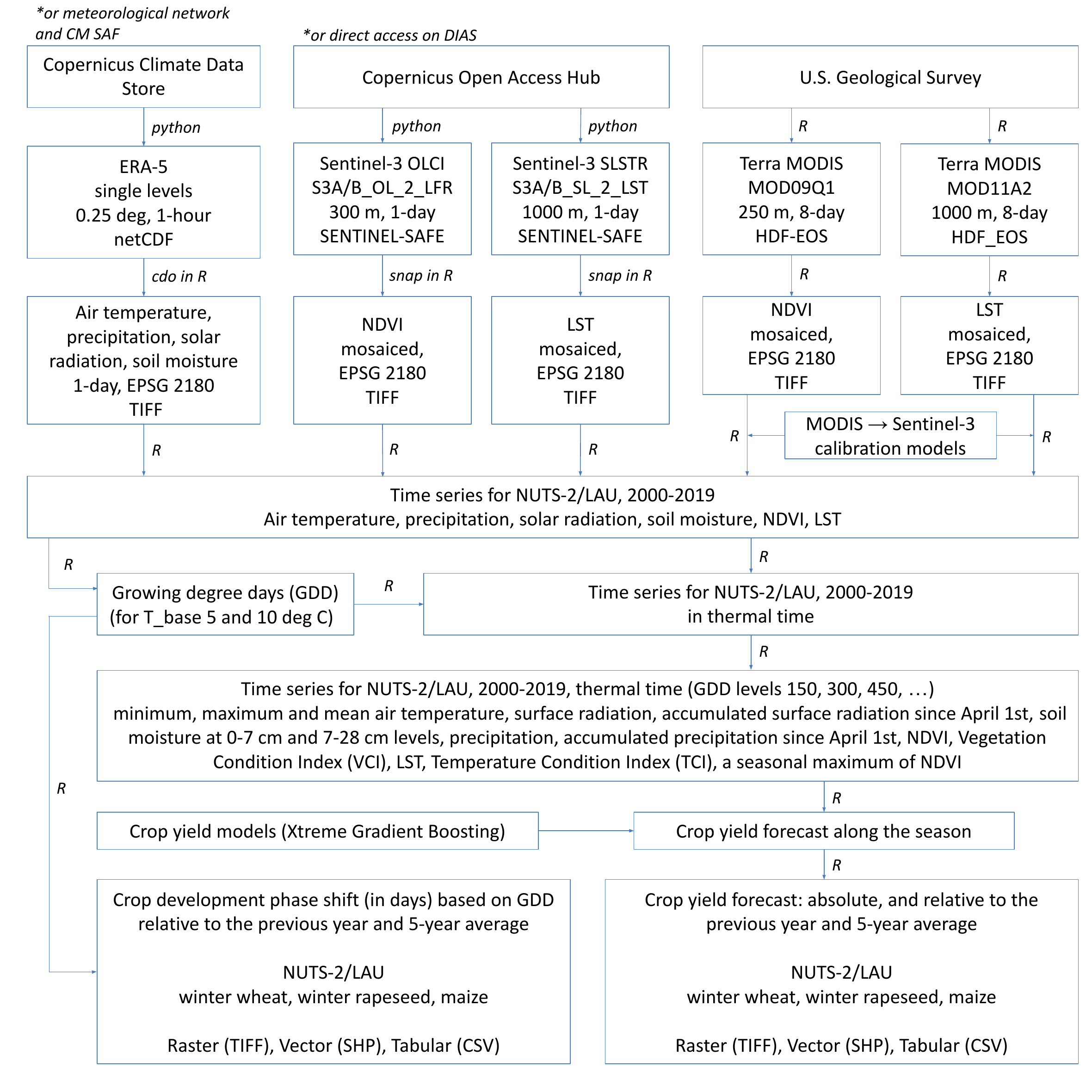
Figure 3. Scheme of the crop yield forecasting system, data streams and software used ('cdo' - Climate Data Operators v1.9.9 , R v4.1.1, Python v3.8.10). The system is able to switch from ERA-5 to data from the national meteorological network and, for surface radiation, to EUMETSAT Satellite Application Facility for Climate Monitoring.
Publications and presentations