

Project IMAGE-UP
The goal of the IMAGE-UP project is to calibrate and validate the super-resolution reconstruction method, with the aim of further applying it to analyses dedicated to three customer sectors: precision agriculture, energy infrastructure managers, and urban space management institutions.
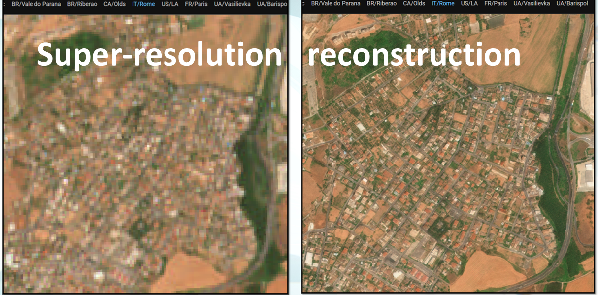
Super-resolution reconstruction involves increasing spatial resolution through the use of mathematical models. This procedure allows us to obtain greater image detail and is able to monitor objects much smaller than in the initial image. The project will use the super-resolution reconstruction method developed by Gamma Earth from Switzerland. This method allows for an increase in the resolution of Sentinel 2 images by up to 10 times. This means that the resolution of the original image of 10 m (a pixel is 10 by 10 m) is increased to 1-2 m.
The project hypothesizes that super-resolution reconstruction affects the accuracy of the spectral response of objects recorded by the satellite. In other words, the image after super-resolution reconstruction may contain incorrect information. To estimate the error and calibrate this method to reduce the error to a level acceptable to end users, the resulting images will be calibrated, meaning the model will be retrained for dedicated application areas, known as use cases. This will improve reconstruction accuracy, and the finished satellite images will therefore achieve higher analytical value.
Based on the calibration and subsequent validation (testing with end users), three algorithms, tailored to aforementioned end users, will be delivered. This process will increase end users’ confidence in this method, intensify the use of the Copernicus programme, and contribute to achieving the SDGs through the use of EO-based technologies.
The project’s results will consist of four new and commercially viable key results: a validated super-resolution reconstruction method and three algorithms based on this data, dedicated to the indicated sectors.
Project leader: Institute of Geodesy and Cartography
Partner: Gamma Earth Sarl / Switzerland
Implementation period: 2025–2028
Funding: National Center for Research and Development
The IMAGE-UP project is funded under the Second Swiss Contribution (Swiss-Polish Cooperation Programme), co-financed by the Government of the Swiss Confederation and the Government of the Republic of Poland, and implemented by the National Centre for Research and Development (NCBR).
Additional information
The target groups of the IMAGE-UP project primarily include end users representing the three sectors covered by the project: precision agriculture, including farms, companies and service providers operating in the agricultural sector; urban area management, including public administration bodies, spatial planning institutions and other entities responsible for sustainable urban development and security; and critical infrastructure, in particular energy infrastructure operators and managers as well as companies providing technologies and services for this sector. The project results are also addressed to companies using Earth Observation (EO) data, research and scientific institutions, universities and other potential users of satellite data.
The total project value is PLN 4,377,117.25, and the amount of funding is PLN 3,977,718.85. The project is implemented under the Research and Innovation Programme – Applied Research within the Swiss-Polish Cooperation Programme.
The project is implemented by an international consortium led by the Institute of Geodesy and Cartography (IGiK), ul. Zygmunta Modzelewskiego 27, 02-679 Warsaw, Poland, tel. +48 22 329 19 00, e-mail: igik@igik.edu.pl, www.igik.edu.pl.
The project partner is Gamma Earth Sarl, Ch. de la Scierie 10, 1162 St-Prex, Switzerland. Contact person: Yosef Akhtman, CEO, tel. +41 75 417 91 29, e-mail: ya@gamma.earth, www.gamma.earth.
More information about the programme and its implementation is available on the official website of the Swiss-Polish Cooperation Programme: programszwajcarski.gov.pl.
IMAGE-UP Project News
Latest information on the implementation of the IMAGE-UP project:
- 03.08.2026 – Acquisition of high-resolution reference data for the verification of IMAGE-UP algorithm performance – UAV survey campaign along the Żerań Canal
- 30.07.2026 – IMAGE-UP Explores Super-Resolution for Hyperspectral Data
- 09.07.2026 – IMAGE-UP Prepares Reference Data Acquisition Campaigns
- 22.06.2026 – IMAGE-UP at the NMSCAA’26 Conference in Bulgaria
- 04.06.2026 – IMAGE-UP Builds a Database for Calibration and Validation
- 07.05.2026 – New Super-Resolution Model Developed in IMAGE-UP
- 02.04.2026 – First Sentinel-2 Super-Resolution Products Ready for Validation
- 06.03.2026 – IMAGE-UP: User Requirements Definition Stage Completed
- 09.02.2026 – IMAGE-UP Living Lab Workshop – Part 2
- 15.01.2026 – IMAGE-UP Living Lab Workshop – Part 1
Procurement / Calls for Tenders
- 17.06.2026 – Request for Quotation No. 3/2026 – UAV surveys and acquisition of RGB and thermal data
- 08.06.2026 – Request for Quotation No. 2/2026 – UAV surveys and acquisition of RGB and thermal data [CANCELLED]
- 17.02.2026 – Request for Quotation No. 1/2026 – provision of consultancy services within the IMAGE-UP project
Living Lab and the latest project information:
News, materials and the IMAGE-UP Living Lab Panel are available at: www.igik.edu.pl/pl/image-up/