Agricultural water pollution derived from remote sensing data
Projekt ESA PECS WATER
Project coordinator: Dr. Eng. Zbigniew Bochenek
Project number: 98098
Duration of the project: 1.07.2011 – 30.06.2013
Title: Application of remotely sensed data for transboundary water resource management
The aim of the project is to create method supporting the management of water bodies by integrating Earth Observation derived land cover / land use information into specialized water quality and agri-economical models. The water quality models aim at delivering spatially explicit (geo-located) information on the potential matter input into the water cycle and the predicted environmental concentration of these matters in the water bodies. Additionally scenarios can be calculated which depict the potential influence of changing agricultural / environmental conditions resulting from dedicated management measures. Final step is to estimate the economic viability of these management measures to ensure acceptable and sustainable programme of measures, as it is required by the Water Framework Directive (WFD).
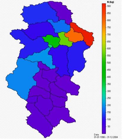 The method elaborated within the project is based on application of models which enable to estimate pollution of surface waters by nitrogen and phosphorus compounds. Two models are tested: SWAT (Soil and Water Assessment Tool) and MONERIS (Modelling Nutrient Emissions in River Systems). Both models are fed with numerous thematic layers, considering various aspects of environment. Land cover / land use map is one of the important layers in both models; it is generated using high-resolution satellite images (IRS LISS 4). Maps of loads of nitrogen and phosphorus compounds in water, as well as other maps describing state of environment within the catchment area, are the final output products from modeling phase.
The project contributes to implementation of the directives of European Commission and UN recommendations, concerning water management (Water Framework Directive - WFD, Nitrates Directive - 91/676/EEC, UN/ECE Task Force on Water Quality Monitoring and Assessment of Transboundary Rivers).