Evaluation of usefulness of ASAR and MERIS images over wetlands
Project leader: dr inż. Maria Gruszczynska (Budzynska)
Duration: 27.03.2003 - 26.03.2005
Evaluation of usefulness of ASAR and MERIS images for studying soil moisture of wetlands
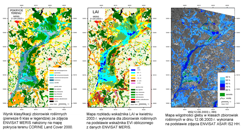
The aim of the project was to analyze possibilities of using ENVISAT ASAR and MERIS images for assessing soil moisture of wetlands. The works were concentrated on the area located at Biebrza Valley. ASAR images registered with various angles and polarizations were analyzed in order to select the optimal parameters of acquisition. MERIS multispectral images were also analyzed and those spectral bands were selected, which characterize in a best way vegetation through EVI index, correlated with LAI index. As a result of the project the method of assessing soil moisture with the use of ENVISAT data collected in optical and microwave bands was prepared. MERIS optical bands were applied for classifying vegetation and for calculating LAI index, which reflects roughness of the examined vegetation canopy. ENVISAT ASAR IS2 HH data were used for calculating backscattering coefficient, which informs about soil moisture for particular vegetation communities divided by various levels of LAI. The algorithms served for making maps of soil moisture. Comparison of maps enables to determine changes of moisture of wetlands within vegetation period and in particular years covered by the study.