Field measurements
 Remote Sensing Centre has been providing field measurements during vegetation time. We measure soil and vegetation indices to check, correlate and compare with the satellite data. Our results are being used in various research projects and grants.
The field studies have been performing over wetlands in Biebrza National Park and arable lands in Wielkopolskie Voivodeship (JECAM), Opolskie and Lubelskie Voivodeships (GYROSCAN project).
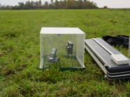
Remote Sensing Centre has the professional equipment for conducting the research. Set of ground measurements include:
- Spectral responses 350 – 2500 nm (2x ASD FieldSpec 4 Hi-Res, MALVERN PANALYTICAL, USA),
- Chlorophyll fluorescence (OS5p+, OPTI-SCIENCES, USA),
- Leaf Area Index (LAI) (2x LAI-2200 Plant Canopy Analyzer, LI-COR, USA),
- APAR ((2x AccuPAR LP-80,DECAGON DEVICES INC., USA),
- Soil moisture (3x TRIME-PICO 64, IMKO, Germany),
- Radiance temperature (Handheld infrared thermometer, EVEREST INTERSCIENCE INC., USA),
- Chlorophyll (FieldScout CM 1000 Chlorophyll Meter, SPECTRUM TECHNOLOGIES, USA),
- Carbon balance (with chamber method and Eddy-Covariance method),
- Biomass wet and dry, water content in biomass
The Remote Sensing Centre has two automatic weather stations (AWS). They collect data for agricultural areas in Greater Poland Voivodeship and over wetlands in the Biebrza National Park. They are equipped with the following measuring sensors:
- Eddy Covariance over Biebrza Wetlands,
- air temperature and humidity,
- an anemometer recording wind speeds and directions,
- net radiometer,
- pyranometer measuring solar radiation in a range of spectra response from 305 to 2800 nm,
- pyrgeometer measures far-infrared radiation in a range of spectra response from 4500 to 50000 nm,
- rain gauge,
- leaf wetness sensor measuring dielectric constant of a zone approximately 1 cm from the upper surface of the sensor,
- soil moisture,
- NDVI sensor.