What we do
The Remote Sensing Center has many years of experience in conducting scientific research and research and development in the field of using aerial and satellite images to obtain information about objects, phenomena and processes taking place on the Earth's surface. The Remote Sensing Center was established in 1976. as the Aerial and Satellite Image Processing Center (OPOLiS) carrying out unique works with the use of modern remote sensing techniques. Currently, the Remote Sensing Center carries out various research topics using optical data (visible, thermal) and radar data, we use the latest satellite imagery from the COPERNICUS Program. They concern:
• AGRICULTURE: forecasting yields, detecting and monitoring droughts, identifying crops, estimating the condition of crops;
• SWAMP AREAS (NATURA2000): energy and water balance, carbon cycle between the surface and the atmosphere, estimation of biomass, research on changes in soil moisture, classification of land cover types and temporal changes;
• BIOENERGY: detection and monitoring of energy plantations;
• NATURAL THREATS: droughts, floods, fires, landslides;
• TERRAIN CHANGES in Natura 2000 areas, agricultural areas, grass areas and urban areas
Remote Sensing Centre
Head of Remote Sensing Centre: prof. dr hab. Katarzyna Dąbrowska-Zielińska
Tel: +48 022 329-19-74
E-mail: katarzyna.dabrowska-zielinska@igik.edu.pl
Deputy manager: mgr Karol Paradowski
Tel: +48 022 329-19-85
E-mail: karol.paradowski@igik.edu.pl
|
|
|
|
|
Yield forecasting, crop growth condition and moisture assessment during the growing season, yield reduction due to unfavorable growth conditions. Detection and monitoring of agricultural drought in Poland. |
Monitoring of the negative effects of climate change such as droughts, floods and all their impacts. Analysis of changes in cloud cover in Poland. Analysis of variability of biomass, soil moisture, evapotranspiration and CO2 fluxes. |
Satellite monitoring of wetland and grassland ecosystems, including RAMSAR areas. Determination of changes in their moisture content and plant cover based on satellite images, modeling of the carbon and energy balance, development of a comprehensive system for managing grassland production. |
|
|
|
|
|
Methodologies for mapping land cover changes based on the analysis of high-resolution satellite images. Development of classification algorithms. Preparation of land cover maps and land cover change maps for the selected areas in Poland and Europe. |
Research related to environmental hazards, primarily ground deformations, fires and flooding. Development of the integrated system for monitoring ground deformations. |
Calibration of satellite measurements and validation of products using in-situ data obtained at the test sites and at the measurement stations. |
.png)
.png)
.png)
.png)
.png)
COMMERCIAL IMPLEMENTATION OF AGRICULTURAL MONITORING
Autonomous solutions introducing dynamic information obtained from the latest satellite data
|
AUTOMATED PROCESS OF ORDERING AND DOWNLOADING REPORTS::
|
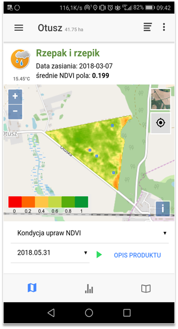 |
MOBILE DATA COLLECTION
|
.png)

CONSULTING AND TRAINING
The Remote Sensing Centre as an expert department conducts and offers various training courses in the field of remote sensing. Satellite and aerial images have enormous information potential, which can be used in many fields of economy.
Please contact us at teledetekcja@igik.edu.pl