Environmental Hazard
Copernicus products and services for management of environment

The Action is principally focused on capacity building and raising awareness of the various stakeholders, responsible in Poland as National Action looking internationally for monitoring and management of the environment, on the scope of applications of the Earth Observation data and services developed in the frame of Copernicus products.
Geo4IRBM - surface derformation monitoring

The aim of the project was rapid elaboration and provision of certain informational products and services which will be further used for the needs of support of selected river basins management. The region of the project implementation was provisionally defined as selected rivers’ watersheds in the western part of Java island, Indonesia. Within the Geo4IRBM project Institute of Geodesy and Cartography was responsible for surface deformation monitoring service.
DefSAR - ground deformations

The main aim of the project is to elaborate the integrated system for monitoring ground deformations using satellite radar interferometry with PSInSAR persistent scatterers, precise levelling and measurements from permanent GNSS stations. The research is carried out within Warsaw area and in its surroundings. The study is done both for large area movements of Warsaw Pan and for local deformations caused by metro construction and other elements of infrastructure.
Fire Monitoring from Space
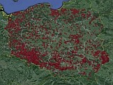
Application of remotely sensed data to the management of fires events in Poland – project funded from European Space Agency (ESA) program PECS.
The hotspot detected from space and fire extend obtained from optical and radar satellite data will be compared with the in situ data from the National Forest Fire Information System managed by the Forest Research Institution.
The hotspot detected from space and fire extend obtained from optical and radar satellite data will be compared with the in situ data from the National Forest Fire Information System managed by the Forest Research Institution.
Fire Intensity Estimation
Dr inż Agata Hościło received a grant from the Fundation of Polish Science - program POMOST (6/2012). Project title: A novel approach to estimate fire intensity and carbon emissions over a decade of fires in Poland.
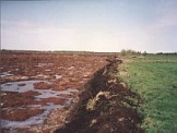
Local flooding with satellite images
Daily registration of NOAA.AVHRR and Terra.MODIS images gives opportunities to observe local floodings in Poland. The obtained images show increased rivel levels in Mazovia, Podlasie and Lubelszczyzna in April 2013. On the elaborated figures there are arrows showed to mark observed local flooding locations. In April there were first in the year field measurements carried out. The photos taken in Biebrza Wetlands with local floodings were also presented.
Satellite-based monitoring crop damages

Observations of areas with frozen winter cereals are made at the Remote Sensing Centre. There are applied optical images registered from satellites NOAA, TERRA and WorldView-2.
Flood extent mapping with microwave satellite images
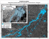
The objective of the ESA project was to assess the area flooded in May and June 2010 in Poland. Data gathered by various satellites with radar sensor were used at the chosen test sites. These included microwave satellite images such as ALOS.PALSAR, ENVISAT.ASAR and ERS-2.SAR. Microwave satellite images were used for mapping the extent of flooding.
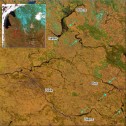
Flooding in the valleys of the Vistula and Odra rivers
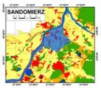
Institute of Geodesy and Cartography once again in its history has used satellite remote sensing methods for mapping flood extent. The accompanying maps present the situation in the valley of the Vistula and San, on 6 June 2010 and in the valley of Odra on 9 June 2010. The flood wave range has been superimposed on a map showing land use in districts located along both sides of the rivers.
Degradation of wetland ecosystems caused by peatland fires
The aim of this project was to develop methods of assessment of degradation of wetland ecosystem caused by the fires that took place in 2002 in the Biebrza Valley National Park (BNP); one of the largest wetland areas in Europe (NATURA2000 and RAMSAR site).
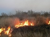
Forest fire risk assessment
In 90s the Remote Sensing Department - IGiK in collaboration with Forest Research Institute (IBL) in Sękocin conducted a study on the use of low resolution NOAA.AVHRR data for forest fire risk assessment over Poland. Satellite images were used to calculate radiative temperature, evapotranspiration and vegetation indices describing changes in spectral characteristics of forest. There parameters showed relatively good correlation with the moisture of litter measured in the forest by the IBL.