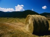
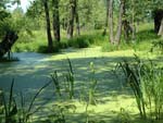
Wetlands and grasslands
Remotely sensed chlorophyll fluorescence measurements in the Biebrza Valley

Within the framework of the project, a new model for predicting spatiotemporal chlorophyll fluorescence will be adapted based on field data, recordings from automatic measurement stations AWS Campbell and ISMN soil moisture networks, as well as satellite vegetation indices. The project is funded under the IGIK Research Fund.
Chlorophyll fluorescence measurements of peatbogs in Biebrza Valley

The main goal of the project is to plan and carry out field measurements of chlorophyll fluorescence at wetlands in Biebrza Valley. In addition a complex database containing groundbased measuremets will be provided to facilitate performing calibration and validation of satellite data. The project is funded by the National Science Centre, Poland (NCN) via MINIATURA 5 grant.
GrasSat - complementary tool for managing grassland production

The main objective of GrasSat project is a fully operational system in form of desktop and mobile application, which provides a complementary tool for managing grassland production, mainly for medium and large farms in Poland and Norway. Combining the effectiveness of the application with the support of external advisors is the key to improve grass production management. Experience of the team of remote sensing and grassland specialists will be the firm foundation of the tools to be prepared within the project.
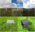
Modelling the carbon balance at wetlands applying Sentinel-1/2/3

The project objective is elaboration of the methodology for carbon balance modelling based on satellite Sentinel-1/2/3 data and insitu measurements of CO2 by chamber method, Leaf Area Index (LAI), soil moisture, PAR, biomass wet and dry (in the laboratory), surface temperature and soil temperature for Biebrza wetlands under changing moisture, biomass and meteorological conditions. The Project is funded by the National Science Centre, Poland (NCN) via OPUS 12 grant no 2016/23/B/ST10/03155.
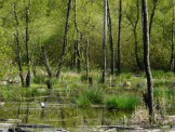
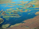
Monitoring wetlands in the trans-boundary Biosphere Reserve West Polesie

The main aim of the project is to exchange experience and knowledge in the use of remote sensed satellite data and technology for monitoring of wetlands located in the transboundary region of Belarus and Poland. The latest European satellites of a series of Sentinel satellites and constellation of the Belarusian-Russian satellites BKA - Canopus will be exploited for assessment of the current state and condition of wetlands in the Biosphere Reserve including analyses of land cover / use and land cover changes and seasonal changes in soil moisture.
Soil moisture, grasslands productivity and crops - ALOS-2 PALSAR-2

The objective of the proposal is development of methods for the assessment of soil moisture and productivity distribution in the area of grasslands and croplands using multi-polarized PALSAR-2 data alone and in conjunction with Sentinel-1/2/3 data. Also, the method for monitoring the changes of grasslands and croplands production caused by drought will be developed.
POLWET - system for monitoring Ramsar sites in Poland

The one of the objectives of the project is to establish wetlands monitoring system and create the dedicated EO-based information service as a platform enabling on-line accessibility of the final products to the end-users, adjustable to user’s needs at local, regional and national level. Evaluation of operational value of EO-based products proposed for wetland management, considering feedback from end-users and validation activities will be performed.
Validation of Sentinel-1 soil moisture products

In the scope of proposed project two S-1 SM validation sites covering grassland and marshland are located in the Biebrza Wetlands (Poland). Environmental conditions between both sites vary in respect to a SM level, vegetations density and type of grass cover. This diversity will allow to evaluate the S-1 SM products across a wide range of conditions and to conduct extensive research concerning water, carbon and energy cycles within a unique wetland ecosystem.
Cooperation with ESA, DLR and JAXA for purchasing microwave images

Microwave images have been applied in IGiK since 1991 when the first ESA satellite ERS-1 was launch. That time IGiK was the only institution in Poland which used these data for research purposes. Thanks to continuation of radar missions such as ERS-2.SAR i ENVISAT.ASAR as well as possibility to receive other microwave data including JERS, RADARSAT and ALOS, IGiK conducted research works within the projects under European Space Agency ESA and Japan Aerospace Exploration Agency JAXA.
FINEGRASS - effect of climatic changes on grassland condition
The Project “Effect of climatic changes on grassland growth, its water conditions and biomass” is funded from Polish-Norwegian Research Programme (http://www.ncbir.pl/en/norwaygrants) operated by the National Centre for Research and Development (NCBiR).
Modelling the carbon balance at wetlands
The subject is the research on estimation of carbon fluxes, and modeling of carbon balance using various satellite data over large homogenous wetlands communities located in the Biebrza National Park.
MS.MONINA - Service for Monitoring NATURA 2000 Habitats

The aim of the project was to create a service for monitoring NATURA 2000 habitats with the use of various remote sensing data. The service was built at three levels: European, national and local level. 17 units representing the research institutions, enterprises and end-users participated in the project.
INTAS - Earth Observation systems to assess the status of Northern Eurasia's peatlands
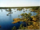
The aim of this project is to develop and test Earth Observation (EO) methods to assess the status of Northern Eurasia's peatlands and associated ecosystems in response to climate change, covering both mitigation and adaptation aspects.
Wetlands monitoring - ALOS satellite
Launch of Japanese ALOS satellite gave new possibilities to apply remote sensing for studying large wetland areas. The aim of the project was to prepare method for monitoring wetland ecosystems and determining soil moisture / vegetation changes on the basis of satellite images ALOS.PALSAR, ALOS.PRISM, ALOS.AVNIR-2 and ENVISAT.ASAR.
Evaluation of usefulness of ASAR and MERIS images over wetlands
The aim of the project was to analyze possibilities of using ENVISAT ASAR and MERIS images for assessing soil moisture of wetlands. The works were concentrated on the area located at Biebrza Valley. ASAR images registered with various angles and polarizations were analyzed in order to select the optimal parameters of acquisition. MERIS multispectral images were also analyzed and those spectral bands were selected, which characterize in a best way vegetation through EVI index, correlated with LAI index.
Method of determining areas with diversified SM within wetlands
The aim of the project was to prepare the method of examining soil moisture and its changes for Biebrza Basin on the basis of information acquired by optical and microwave satellites. This information will be used for evaluation of changes of water regime with the study area. The study was done for 1995-2002 period.