INTAS - Earth Observation systems to assess the status of Northern Eurasia's peatlands
![]() INTAS - ESA Thematic Call on Earth Science and Environment 2006
INTAS - ESA Thematic Call on Earth Science and Environment 2006
6 Framework Programme
Remote sensing methods for environmental assessment of Eurasian peatlands and associated ecosystems under climate change (PACINE) (from 2007 to 2009)
Poland is member of INTAS (International Association for the promotion of cooperation with scientists from the New Independent States of the former Soviet Union) from 18 of august 2002.
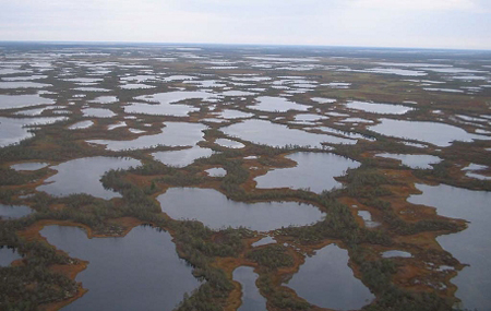
 The aim of this project is to develop and test Earth Observation (EO) methods to assess the status of Northern Eurasia's peatlands and associated ecosystems in response to climate change, covering both mitigation and adaptation aspects. To cover gaps in existing data on peatlands extent and diversity in Eurasia, we will investigate the possibilities to use MODIS satellite data for mapping of large-scale peatland areas in boreal and temperate zones, and we will produce a 250-m resolution map of peatlands and associated ecosystems in Eurasia. The grid-based ground truth database will be used to calibrate and validate methods and EO-derived thematic products.
Human activities threaten peatlands, and the UNFCCC states the peat excavation is the most important disturbance factor related to climate change. By combining moderate and high-resolution EO data supported by ground truth information, peatlands excavated at different stages will be detected and monitored. Both historical and recent high-resolution data (e.g. Landsat TM/ETM+, Meteor 3M/MSU-E, etc.) will be used to derive spatially explicit maps and estimates of excavated peatlands over test regions in Europe and Western Siberia covering a wide range of virgin and disturbed peatlands. Peatlands play a significant role in greenhouse gas (GHG) fluxes; these fluxes vary strongly in time and space. We will focus on the development of methods to derive spatially and temporally explicit estimates of GHG fluxes in peatland ecosystems by combining EO data and pointwise in-situ measurements.
Climate change effects biomass structure and composition, which in turn impacts animal habitat. One sub-project focuses on modeling soil wetness and water habitat for better understanding the role of micro-habitat ( i.e. vegetation type and structure, water absorbing capacity and mix of organic to mineral matter) in the current distribution and abundance of amphibian and reptile species in peatlands and associated ecosystems. Future species distributions will be simulated in response to (micro) habitat changes within these ecosystems. The project is a response to the Call on Global Climate Change Focusing on Carbon Stocks and Changes in Biodiversity and addresses pan-European scientific co-operation in order to further develop EO missions and technology for environmental assessment.
 Project participants:
- Institute of Geodesy and Cartography - IGiK (prof. Katarzyna Dabrowska-Zielinska)
- International Institute for Geo-Information Science and Earth Observation - ITC (prof. Andrew Skidmore)
- Federal Centre of Geoecological Systems - FCGS (dr Tatiana Minaeva)
- Space Research Institute - IKI (dr Sergey Bartalev)
- Institute of Forest Science - IFS (dr Andrey Sirin)