Determination of acreage and structure of crops with the use of aerial and satellite remote sensing
Determination of acreage and structure of crops with the use of aerial and satellite remote sensing
Project IGIK PC-1
Project leader: Prof. dr hab. Andrzej Ciołkosz
01.07.1997-01.04.1999
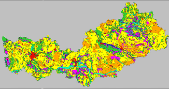 As a result of this project the method of estimating acreage and structure of crops in Poland with the use of satellite and aerial images was prepared. Various approaches to stratification of agricultural land were tested in the course of the project, in order to choose the optimal method for selecting test areas. Distribution of agricultural land in Poland was determined on the basis of analysis of Landsat TM satellite data. Next stratification of agricultural land was done into 3 layers, different in intensity of production. Stratification map was a basis for selecting test areas distributed within particular voivodships according to the rule of mathematical statistics. At the next stage of the works field interpretation of structure of crops was done within test areas, using aerial photographs for this purpose. Information about crop structure was next processed, in order to determine acreage on the main crops within boundaries of particular voivodships.
In 1998 vegetation period the described method was applied for determining acreage of the main crops for 40 % of the country. The obtained results were finally compared with the results of agricultural census done by the Head Statistical Office, in order to asses accuracy and effectiveness of remote sensing based method prepared at the Institute of Geodesy and Cartography.