Forests
Preparation of the forest biomass maps for Poland

The main purpose of the ESA Due GlobBiomass project is to better characterize and to reduce uncertainties of forest aboveground biomass estimates by developing an innovative synergy mapping approach in five regional sites for the epochs 2005, 2010 and 2015 and for one global map for the year 2010. The project team includes the leading Earth Observation experts of Europe (14 institutions from 8 European countries) and is linked through Partnerships Agreements with further national bodies from Brazil, Canada, Chine, Russia and South Africa.
Remote sensing based assessment of woody biomass and carbon storage in forests

The role of the Remote Sensing Center of IGIK is to investigate and develop methods for forest above ground biomass retrieval based on various satellite radar data i.e. ALOS-2 (L-band), Sentinel-1 (C-band), TerraSAR-X (X-band) that will be suitable for forest habitats and types present in Poland. The forest inventory data collected during the RemBioFor project will be used as the reference data.
Inventory of actual forest extent
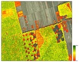
The aim of the project was to map the actual forest extent over Poland using the following spatial data sets: Digital Forest Map, Topographic Database, Database of Parcel Identification System, High Resolution Forests layer (HRL - Copernicus product), and Forest Data Bank.
WICLAP - effects of winter climate change and air pollution on forests
The Project “Ecosystem stress from the combined effects of winter climate change and air pollution - how do the impacts differ between biomes?” is funded from Polish-Norwegian Research Programme (http://www.ncbir.pl/en/norwaygrants) operated by the National Centre for Research and Development (NCBiR).
Forest damages

For monitoring of forest damages the satellite images taken in 2000 and 2006 were applied. The observations were conducted at the area of Pisz forest, the Slovak Tatra Mountains and the forests along A1 and A4 motorway construction sites. The research was performed under European FP7 Geoland2 project.