Services for Earth Observation-based statistical information for agriculture
ESA EOStat: Agriculture Poland: Services for Earth Observation-based statistical information for agriculture
Project funded by the European Space Agency.
Principal Investigator: Jędrzej Bojanowski, PhD
Project team (at IGiK): Jędrzej Bojanowski, Jan Musiał, Sylwia Sikora
Project partners: Institute of Geodesy and Cartography, Space research Center of Polish Academy of Sciences, Statistics Poland (Steering Board), Agency for Restructuring and Modernisation of Agriculture (ARMA)
Project duration: 15.05.2018 – 30.11.2021
Project aims
- Developing an EO-based system to support operational activities of Statistics Poland related to gathering statistical information on agriculture.:
- crop type classification
- crop growth monitoring and yield forecasting
- Developing an EO-based system to support verification of farmers’ obligations under the Common Agricultural Policy (for the Agency for Restructuring and Modernisation of Agriculture) :
- Crop diversification
- Agricultural activities obligations
- Maintenance of ecological focused areas (EFA)
Crop yield forecasting system in Statistics Poland
The project has developed a fully automatic operational system for forecasting yields of main agricultural crops at the provincial (NUTS-2) and municipal level (LAU). The system utilizes machine learning methods, i.e. Xtreme Gradient Boosting. Yield predictors consist of calibrated satellite data in the optical and thermal domain acquired by Terra/Aqua MODIS and Sentinel-3 satellites, as well as agro-meteorological data from the measurement network of the Institute of Meteorology and Water Management, ERA-5 climatological reanalysis and CM SAF data. The system was developed on the basis of R computing environment and implemented within the SATMIROL project in the Statistics Poland. The system provides continuously updated forecasts during the growing season. Below is an example of the result of the forecasts for 2021.

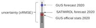
The produced forecasts are evaluated and compared with the forecasts and final estimates of the Statistics Poland. The figure below shows the result of forecasts for 2020 made by EOStat forecasting model (bars), the Statistics Poland expert estimate (blue dots) and the Statistics Poland final estimate (red dots).

Satellite-based system to support control of compliance with the rules of the Common Agricultural Policy regarding direct payments
As part of the project, a system based on Sentinel-1 (radar) and Sentinel-2 (optical) data was developed which provides information for individual parcels on the correctness of the declared crop, sowing date (greening), harvesting date, presence of vegetation cover to prevent soil erosion or presence of catch crops. The system have been implemented for the Agency for Restructuring and Modernisation of Agriculture on the CreoDIAS cloud computing platform. Access to reports for individual parcels (all parcels in Poland meeting the field size criterion) is possible through the WMS service or direct queries to the PostGIS database. Figure below shows an example report.

Use of high resolution data for analysis of small and narrow parcels
Small and/or narrow parcels are numerous in Poland. Crop analysis on these parcels is not possible on Sentinel-2 data due to too low spatial resolution. Therefore, within the framework of the EOStat project, in cooperation with Planet and Cloudferro, we have performed a study of the usefulness of Planet FUSION (3 m) and S2-enhancer (2.5 m) data for the determination of EOStat products: crop recognition and detection of agrotechnical activities.


Left: Sentinel-2 RGB 10m x 10m image. Right: Enhanced Sentinel-2 RGB imagery at 2.5m x 2.5m resolution generated by the CREODIAS cloud.
The FUSION and S2-enhancer images are modelled data. Planet FUSION data, as a result of spatio-temporal interpolation of observational data, provide daily cloud-free images. S2-enhancer data, on the other hand, are data with increased spatial resolution (up to 2.5 metres) as a result of machine learning. Our analysis included evaluating the radiometric validity of the data and the stability of the vegetation indices (below).


Additional work
- Analysis of requirements of Statistics Poland and the Agency for Restructuring and Modernization of Agriculture (EOStat project end users) concerning functionality of the system of satellite data usage for public administration.
- Application of Sen2Agri/Sen4CAP system for crop classification based on Sentinel-1, Sentinel-2 and Landsat-8 data on CreoDIAS platform.
- Feasibility study of field-level crop yield forecasting using Sentinel-2, Landsat 7 and 8, and agro-meteorological data.
EOStat in the media
Sentinel data enables new system for agricultural monitoring in Poland
Ile i czego jest na polach? Teledetekcja satelitarna prawdę powie?
Migracja aplikacji Instytutu Geodezji i Kartografii do chmury AWS w ramach AWS PoC
Project dissemination
Bojanowski J., Sikora S., Musiał J., 2021, Predicting crop yields with Copernicus and SAFs’ data for national agricultural statistics, EUMETSAT Meteorological Satellite Conference, Bucharest, Romania.
Bojanowski J.S., Woźniak E., Aleksandrowicz S., Bochenek Z., Dąbrowska-Zielińska K., Lewiński S., Malinowski R., Musiał J.P., Rybicki M., Sikora S., Milewski T., Mleczko M., Sas S., Łączyński A., Services for EO-based statistical information for agriculture and verification on farmers’ obligations under Common Agricultural Policy, EARSeL 2021, European Remote Sensing-New Solutions for Science and Practice, Warsaw, Poland.
Bojanowski J.S., Musiał J.P., Sikora S., Woźniak E., Rybicki M., Aleksandrowicz S., Malinowski Milewski T., Łączyński A., Burzykowska A., 2021, Services for Earth-Observation-based statistical information for agriculture, Conference on New Techniques and Technologies for Statistics, Brussels, Belgium.
Musiał J., Bojanowski J., 2020, Satellite surveillance of agriculture: BigData analysis using AWS, CREODIAS, and Google Earth Engine cloud computing services leverages agricultural monitoring for public administration, Data Science Summit 2020, Warsaw, Poland.
Bojanowski J.S., Woźniak E., Aleksandrowicz S., Bochenek Z., Dąbrowska-Zielińska K., Gatkowska M., Lewiński S., Musiał J.P., Paradowski K., Rybicki M., Ziółkowski D., Mleczko M., Milewski T., Slesiński P., Łączyński A., EOStat – Agriculture Poland: Services for Earth Observation-based statistical information for agriculture, ESA Living Planet Symposium 13-17 May 2019, Mediolan. POSTER
Bojanowski J., Woźniak E., Voormansik K., Aleksandrowicz S., Bochenek Z., Dąbrowska-Zielińska K., Lewiński S., Malinowski R., Musiał J., Rybicki M., Milewski T., Slesiński P., Sas S., and Łączyński A., 2019, EOStat – Agriculture Poland: Services for EO-based statistical information for agriculture and verification on farmers’ obligations under CAP. 25th MARS conference, Praga. POSTER
Musiał J., Bojanowski J., 2019, Assessing potential of the Sentinel-2 imagery for monitoring of agricultural fields in Poland. 25th MARS conference, Praga. POSTER