Sentinel-2 national mosaic
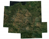
National mosaic of Sentinel-2 for 2018
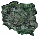
A mosaic of images recorded by European Sentinel-2 satellites covers the territory of Poland, including a 10-kilometer buffer from the country's borders. The mosaic was generated by combining cloud-free satellite images recorded between April 1 and October 30, 2018 (87 images in total).The mosaic is available free of charge in RGB colour composition (channels 4, 3, 2), with a spatial resolution of 10 meters.
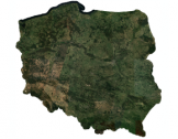
National mosaic of Sentinel-2 for 2019
The Center for Applied Geomatics has developed a mosaic of images recorded by the European Sentinel-2 satellites, covering the territory of Poland. The mosaic was generated based on a composite combination of cloud-free satellite images recorded between May 1 and October 30, 2019 (404 satellite scenes in total). The mosaic is available free of charge in RGB colour composition (channels 4, 3, 2), with a spatial resolution of 10 meters.
National mosaic of Sentinel-2 for 2020
National mosaic of Sentinel-2 for 2021
National mosaic of Sentinel-2 for 2022