Land cover and land use monitoring
Norway Grants - InCoNaDa
InCoNaDa - Enhancing the user uptake of Land Cover / Land Use information derived from the integration of Copernicus services and national databases. The main goal of the InCoNaDa project is to improve the user uptake of land cover and land use information derived from the integration of Copernicus Land Monitoring Services (CLMS) and national databases.
Copernicus Land Monitoring - Poland

Change detection and monitoring
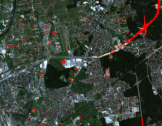
Detection of changes occurring on the earth's surface and monitoring of their dynamics and direction is required in many areas of economy. On the basis of analysis of multi-temporal satellite or aerial imagery, we can obtain information about the size, direction and time when the change occurred. In case of small topographic or infrastructural objects often aerial images or commercial satellite images with very high spatial resolution are used.