Crisis management
In crisis management, the access to reliable, up-to-date information and the flow of information between authorities and structures responsible for crisis management is crucial. It is important for prevention, monitoring of a crisis situation and for taking the right decisions while removing their effects.
Fires
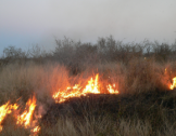
Integration of available geospatial data and access to reliable and up-to-date information about the situation during a fire are crucial in crisis management and helps to make the right decisions. Aerial and satellite images are widely used in the observation and analysis of the phenomenon of fires and in monitoring the situation after a fire. Using the Earth Observation data, we are able to obtain information on burned area, fire intensity, fire location, type of land cover classes affected by the fire. This information is the starting point for spatial and statistical analyses aimed at estimating the fire damages.
Wiatrołomy
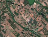
Extreme weather events such as hurricanes, floods or fires become more and more common phenomena in Europe. In August 2017, strong wind accompanied by heavy thunderstorms caused severe damage over the large area in central and western Poland. According to rapid damage assessment prepared by the State Forests authorities a few days after the windthrow, ca 79.7 thousand hectares of forest was damaged and 9.8 million of cubic meters of wood was lost. Assessment of such a large−scale forest damage is difficult without using the remote sensed data. In this study, we examined the potential of the European satellite Sentinel−2 data for assessment of the forest damage caused by the windthrow.
Forest Degradation
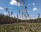
We are carrying out the analysis of the degradation of forest stands caused by prolonged periods of water shortage and insects and pathogens outbreaks using a time series of the European Sentinel-2 datasets. The health condition of the forest is monitored based of a combination of spectral indicators derived from the Sentinel-2 data. Integration of the satellite-based forest condition indicators and the information on the forest characteristics, age, species composition, forest history and habitats allow to better understand the vulnerability of the particular forest stands to prolonged droughts and gradation of insects. The forest condition indicator developed by our team is provided as one of the forest-related products in the SAT4EST application.