Badanie intensywności pożarów - stypendium
Duration of the project: 1.05.2013 – 30.04.2015
About the project
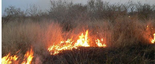
Poland has witnessed an increasing trend in number of fires over the last decades. Statistics provided by the Join Research Centre in Ispra show that Poland is a third European country in number of fires reported annually. It is important, therefore, to examine the causes and consequences of fires in various regions of Poland. To date fire monitoring in Poland is carried out explicitly on the ground and the Earth Observation data, which are recognised as valuable source of information about fire event, are not considered. This project will apply a novel satellite-based approach to fire intensity and fire emissions assessment to better constrain the likely contribution made by Polish fires to climate change. This innovative research project will lead to a reduction in the uncertainties surrounding estimates of carbon losses and emissions from fires. It will also provide best possible data on fire regime dynamics and information on illegal early spring burning.
This project will address the following research objectives:
1) Quantification of the spatial and temporal pattern of fires and investigation of changes in fireregime in Poland over the last decade.
2) Investigation of fire intensity and identification of areas particularly vulnerable to spring burning.
3) Estimation of the amount of carbon dioxide, carbon monoxide and methane released through biomass combustion using innovative state of the art satellite based method (‘top down’ approach).
Scientific partner:
The Department of Geography, University of Leicester (UK) has over 15 years of experience in mapping fire scars and evaluating their impact on environment and society in various ecosystems. The collaboration will be focused on know how exchange about retrieval of fire intensity and estimation of emissions from remote sensed data over Poland. Both institutions are very much aware of the need for accurate information on fire damage and disturbance because of the need to report emissions and damage to agricultural regions.
Stipend offer:
We offer a master thesis stipend in the Department of Remote Sensing, Institute of Geodesy and Cartography in Warsaw. The competition is opened to MSc students who completed BSc study in an area of Physical Geography, Geosciences, Environmental Science or an allied disciplines. The student will be involved in the scientific investigations of the project and will work on his/her MSc dissertation under the Dr. Agata Hościło supervision (Principle Investigator of the project). More information about the stipend offer:
Więcej informacji na temat projektu