Monitoring pożarów z satelity
 Application of remotely sensed data to the management of fires events in Poland – project funded from European Space Agency (ESA) program PECS.
Duration of the project: 1.03.2013 – 30.12.2015
Project manager: Agata Hościło
e-mail: agata.hoscilo@igik.edu.pl ; phone: +48 22 3291976
About the project:
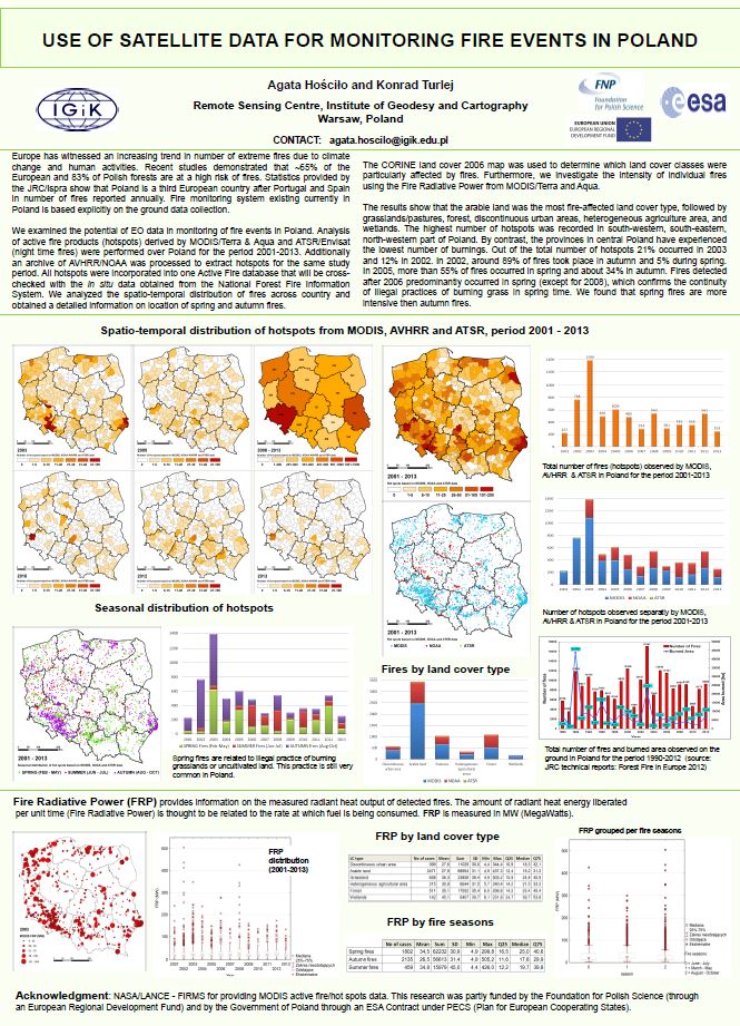
Fire monitoring in Poland is explicitly conducted using ground reporting and measurements through generating burn scars contours. Ground data collection is usually time consuming and cost ineffective especially at large scale as national and sub-national levels. It is important, therefore, to incorporate Earth Observation data in the fire monitoring service.
In this project a set of spaceborne data is applied:
i) to detect fire events from space using active fire products so-called hot spots from MODIS Terra/Aqua satellites and from the AATSR night-time sensor as well as from archive of the AVHRR/NOAA data. Detected active fires will be incorporated into space-based fire database for Poland for the period 2001-2014.
ii) to examine the use of high resolution optical (e.g. ASTER/Terra, SPOT) and radar data (ENVISAT) for burn scars mapping (selected archive fires); and to examine the utility of Sentinel-1 for burn scars mapping.
iii) to assess dynamics of post-fire vegetation regrowth using remote sensed techniques for the selected archive burn scars.
The hotspot detected from space and fire extend obtained from optical and radar satellite data will be compared with the in situ data from the National Forest Fire Information System managed by the Forest Research Institution.
Project partners:
Department of Forest Fire Protection of the Forest Research Institute
News:
The first experimental burning in moorland in Poland was recorded by Landsat satellite
 The first experimental burning in moorland was conducted by the State Forests on March, 18, 2015 in the Przemków Forest District (Dolnosląskie Voievodship). The prescribed burning covered more than 5 hectares of moorland. Satellite image Landsat ETM+ acquired one day after the experimental burning (19 March 2015 at 9:50 UTC) clearly showed the burn scar and increased temperature.
Top image illustrates burn scar visible on Landsat ETM+ image that was acquired 19 March 2015, 9: 50 UTC (band composite 5, 4, 3). The image was obtained one day after the prescribed burning in moorlands in Poland.
Down image shows the temperature distribution (in degree Celsius) in the area affected by fire and surroundings. The temperature was calculated based on the thermal band recorded by Landsat ETM+ 19 March 2015. One day after the fire the burn scar was still warm. The satellite image was processed and analyzed in the Remote Sensing Centre at the Institute of Geodesy and Cartography in Warsaw.
More information about fire-related projects conducted in the Remote Sensing Centre: LINK
More information about the experimental burning: LINK
Publications:
 Hościło A., Turlej K., 2013, Using active fires to detect fires across vegetation types in Poland, the 9th EARSeL Forest Fire Workshop in Coombe Abbey, UK, 15-17 October 2013.
Hościło A., Turlej, K., Napiórkowska, M., 2014, Can remotely sensed data be used to support monitoring of fires in Poland?, Proc. of the 34th Earsel Symposium 2014, 16-20 June 2014, Warsaw, Poland.
Hościło A., 2014, Satelita wykryje pożar? Las Polski, 21/2014
Hosciło A., Turlej K., 2014, Wykorzystanie danych satelitarnych do monitorowania pożarów w lasach. Rogów, 16-18 September 2014.
Important links:
Forest Fire Danger map prepared by the Forest Fire Protection Laboratory
http://bazapozarow.ibles.pl/zagrozenie/